


En primer lugar, te recordamos que puedes navegar por el mapa presionando y arrastrando para desplazarte, y cambiar el zoom mediante la rueda del ratón o los botones “+” y “-” de la esquina superior izquierda.
First, we'd like to remind you that you can navigate the map by clicking and dragging to move around, and adjust the zoom level using the mouse wheel or the “+” and “-” buttons in the upper-left corner.
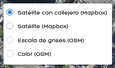
También puedes cambiar la imagen que te enseñamos en el mapa mediante el selector de la esquina inferior derecha, pudiendo seleccionar un mapa en blanco y negro, uno a color o fotografías satelitales, con o sin información sobre las calles (estas últimas son especialmente útiles si necesitas localizar un elemento concreto en el mapa).
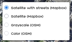
You can also change the view shown on the map using the selector in the lower-right corner, choosing between a black-and-white map, a color map, or satellite images, with or without street information (the latter are especially useful if you need to locate a specific feature on the map).
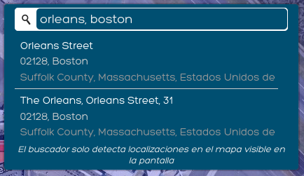
En la esquina superior derecha dispones de un buscador de direcciones que te puede resultar de ayuda para buscar localizaciones en el mapa. Simplemente escribe una dirección, separando los componentes con comas, y pulsa en la lupa o presione la tecla “Intro”. Si solo hay un resultado, el mapa hará zoom a él automáticamente, y si encuentra más de uno, entonces deberás seleccionar el que te interese del listado que se te enseña. Conviene aclarar que la búsqueda sólo se realiza en el área que está visualizando en ese momento (e.g. si el mapa está visualizando sólo Eagle Hill, no podrás buscar una dirección de Jeffries Point, sino que antes deberías disminuir el zoom o desplazarte por el mapa hasta que en él aparezca el área de Jeffries Point).
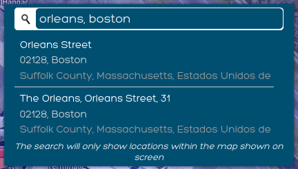
In the upper-right corner, there is an address search bar that can help you find locations on the map. Simply type in an address, separating the components with commas, and click the magnifying glass or press the “Enter” key. If there is only one result, the map will automatically zoom in on it; if it finds more than one, you’ll need to select the one you’re interested in from the list that appears. It’s important to note that the search is limited to the area currently displayed on the map (e.g., if the map is showing only Eagle Hill, you won’t be able to search for an address in Jeffries Point; instead, you’ll need to zoom out or scroll the map until the Jeffries Point area appears).
A la hora de definir lugares en el mapa de Lower East Boston, deberás marcar cada lugar sobre el propio mapa antes de aportar la información concreta sobre el mismo. Para ello, en la parte izquierda puedes encontrar una barra con una serie de botones que te permiten señalar dichos lugares:
When identifying places on the map of Lower East Boston, you must mark each location directly on the map before providing specific information about that location. To do this, on the left side of the screen, you’ll find a toolbar with a series of buttons that allow you to mark these locations:
sirve para trazar líneas en el mapa (e.g. para marcar una calle o un fragmento de acera). Una vez seleccionada, debes hacer clic en el mapa en el punto inicial de la línea y, a continuación, volver a hacer clic en cada uno de los vértices que definen su trazado. Para terminar de dibujar, debes hacer clic de nuevo en el último vértice o pulsar el botón «Terminar» situado junto al botón de la barra de herramientas de la izquierda. Mientras la herramienta está activa, también hay un botón junto a ella en la barra de herramientas de la izquierda que permite eliminar el último vértice dibujado. En cualquier momento podemos pulsar el botón «Cancelar», situado junto al botón de la herramienta, para descartar la inserción del lugar.
used to draw lines on the map (e.g., to mark a street or a section of a sidewalk). Once selected, click on the map at the starting point of the line, and then click again on each of the vertices that define its path. To finish drawing, click again on the last vertex or press the “Finish” button located next to the button on the left toolbar. While the tool is active, there is also a button next to it on the left toolbar that allows you to delete the last vertex you drew. At any time, you can click the “Cancel” button, located next to the tool button, to discard the insertion of the place.
sirve para dibujar polígonos en el mapa (e.g. para marcar una manzana o un conjunto de calles cercanas). Una vez seleccionada, debes hacer clic en el primer vértice y, a continuación, volver a hacer clic en cada uno de los vértices que definen la zona. Para terminar de dibujar y cerrar el polígono, hay que hacer clic de nuevo en el primer vértice, hacer doble clic en el último vértice dibujado o pulsar el botón «Finalizar» situado junto al botón de la barra de herramientas de la izquierda. Mientras la herramienta está activa, también hay un botón para eliminar el último vértice dibujado junto a su botón en la barra de herramientas de la izquierda. En cualquier momento, podemos pulsar el botón «Cancelar», situado junto al botón de la herramienta, para descartar la inserción del lugar.
used to draw polygons on the map (e.g., to mark a block or a group of nearby streets). Once selected, click on the first vertex, and then click on each of the vertices that define the area. To finish drawing and close the polygon, click the first vertex again, double-click the last vertex you drew, or click the “Finish” button next to the button on the left toolbar. While the tool is active, there is also a button to delete the last vertex drawn next to its button on the left toolbar. At any time, you can click the “Cancel” button, located next to the tool button, to discard the insertion of the place.
sirve para marcar puntos en el mapa (e.g. para marcar intersecciones o cruces de peatones). Solo tienes que hacer clic en el mapa en el punto que quieras marcar. En cualquier momento puedes hacer clic en el botón «Cancelar», situado junto al botón de la herramienta, para descartar la inserción del lugar. Esta herramienta está seleccionada por defecto cuando entras al mapa para marcar lugares.
used to mark points on the map (e.g., to mark intersections or crosswalks). Just click on the map at the point you want to mark. You can click the “Cancel” button next to the tool button at any time to discard the insertion of the place. This tool is selected by default when you open the map to mark places.
sirve para editar líneas, polígonos y puntos definidos previamente. Una vez seleccionados, puedes mover vértices de las líneas y los polígonos o los marcadores de los puntos haciendo clic y manteniendo pulsado sobre ellos. También puedes crear nuevos vértices haciendo clic y arrastrando los marcadores translúcidos que aparecen entre los vértices existentes. Cuando estés satisfecho/a con los cambios, debes pulsar el botón «Guardar» que aparece junto al botón de la herramienta para confirmar los cambios. En cualquier momento podemos hacer clic en el botón «Cancelar» situado junto al botón de la herramienta para descartar los cambios. La herramienta permanecerá deshabilitada mientras no hayas señalado al menos un lugar.
used to edit previously defined lines, polygons, and points. Once selected, you can move the vertices of lines and polygons or the markers of points by clicking and holding on them. You can also create new vertices by clicking and dragging the translucent markers that appear between existing vertices. Once you are satisfied with the changes, click the “Save” button next to the tool button to confirm the changes. You can click the “Cancel” button next to the tool button at any time to discard the changes. The tool will remain disabled until you have marked at least one place.
sirve para eliminar líneas, polígonos y puntos definidos anteriormente. Una vez seleccionada, puedes hacer clic en los distintos elementos para eliminarlos. Cuando estés satisfecho/a con los cambios, debes hacer clic en el botón «Guardar», que aparece junto al botón de la herramienta, para confirmar las eliminaciones. Los lugares también se pueden eliminar individualmente utilizando el botón «Borrar lugar» que aparece en su formulario (como se explica en el siguiente párrafo). Al eliminar mediante el botón del formulario, no es necesario confirmar la eliminación, ya que ésta se produce de forma inmediata. En cualquier momento podemos pulsar el botón «Cancelar», situado junto al botón de la herramienta, para descartar los cambios. Además, cuando la herramienta está seleccionada, aparecerá un botón «Borrar todo» junto al botón de la barra de herramientas de la izquierda que nos permite eliminar todos los elementos dibujados en el mapa (ten cuidado, ya que esta opción no requiere confirmación). La herramienta permanecerá deshabilitada mientras no hayas señalado al menos un lugar.
used to delete previously defined lines, polygons, and points. Once selected, you can click on the various elements to delete them. When you are satisfied with the changes, click the “Save” button, which appears next to the tool button, to confirm the deletions. Places can also be deleted individually using the “Remove place” button that appears on their form (as explained in the following paragraph). When deleting using the button on the form, you do not need to confirm the deletion, as it takes place immediately. At any time, you can click the “Cancel” button, located next to the tool button, to discard the changes. In addition, when the tool is selected, a “Remove all” button will appear next to the button on the left toolbar, allowing you to delete all elements drawn on the map (be careful, as this option does not require confirmation). The tool will remain disabled until you have marked at least one place.
Por cada lugar que marques en el mapa, te mostraremos un pequeño formulario en el que deberás indicar unos pocos datos sobre dicha localización antes de poder definir otros lugares o continuar con el cuestionario. Si no dispones de los datos adecuados para el lugar señalado, solo tienes que hacer clic en el botón «Cancelar» para cancelar su inserción. Una vez que hayas rellenado los campos, haz clic en «Aceptar» y podrás marcar nuevos lugares en el mapa o volver a la encuesta. Si necesitas revisar los datos aportados anteriormente para un lugar, haz clic en su icono (geometría o marcador) en el mapa para volver a abrir el formulario.
For each place you mark, we’ll display a short form where you'll need to indicate some data about said location before you can mark other locations or continue with the survey. If you don’t have the necessary information for the location you’ve marked, simply click the “Cancel” button to cancel the entry. Once you’ve filled out the fields, click “Accept,” and you’ll be able to mark new locations on the map or return to the survey. If you need to review the information you previously entered for a location, click its icon (geometry or marker) on the map to reopen the form.
Te pedimos que hagas todo lo posible por definir correctamente los lugares en el mapa siguiendo una serie de recomendaciones:
We ask that you do your best to accurately identify places on the map by following a series of recommendations:
Desplázate por el mapa correctamente hasta que el elemento que deseas marcar sea claramente visible y esté bien definido. Utiliza siempre el nivel de zoom más alto posible que te permita definirlo con precisión, preferiblemente sin tener que mover el mapa mientras dibujas los vértices.
Pan the map until the feature you want to mark is clearly visible and well-defined. Always use the highest zoom level possible that allows you to define it accurately, preferably without having to move the map while drawing the vertices.
En el caso de las líneas y los polígonos, recuerda que, si es necesario, puedes desplazarte por el mapa y cambiar el nivel de zoom mientras dibujas los vértices. Sin embargo, como mencionamos en el punto anterior, por comodidad recomendamos, siempre que sea posible, dejar el elemento totalmente visible y definible en el mapa antes de activar las herramientas de dibujo.
For lines and polygons, remember that, if necessary, you can pan the map and change the zoom level while drawing the vertices. However, as we mentioned in the previous point, for convenience, we recommend, whenever possible, keeping the element fully visible and selectable on the map before activating the drawing tools.
Intenta utilizar el tipo de dibujo más adecuado para cada tipo de elemento. Por ejemplo, utiliza líneas para definir calles o carreteras, polígonos para definir áreas extensas y puntos para elementos discretos o de poca extensión.
Try to use the most appropriate drawing type for each type of feature. For example, use lines to define streets or roads, polygons to define large areas, and points for discrete or small features.
No te preocupes por añadir elementos de todos los tipos de dibujo; lo importante es proporcionar la información que conoces y que consideras útil (por ejemplo, si solo conoces elementos definibles como áreas, no fuerces la introducción de alguno como puntos o líneas).
Don't worry about adding elements from all types of drawings; the important thing is to provide the information you know and consider useful (for example, if you only know elements that can be defined as areas, don't force yourself to include some elements as points or lines).
Procura que los elementos que dibujes no se superpongan entre sí, especialmente los polígonos.
Try to make sure that the elements you draw do not overlap, especially polygons.
Si las herramientas para dibujar líneas y polígonos te resultan demasiado complejas y no logras utilizarlas, antes de dejar el mapa en blanco te pedimos que intentes definir los elementos como puntos, ya que la herramienta es mucho más sencilla (un punto por elemento en este caso; no señales un punto por cada vértice de una manzana ni nada similar).
If you find the tools for drawing lines and polygons too complicated and can't figure out how to use them, before leaving the map blank, please try defining the elements as points, since this tool is much simpler (one point per element in this case; do not mark a point for each corner of a block or anything like that).
Cuando estés satisfecho/a con la información proporcionada en el mapa, haz clic en «Confirmar lugares y volver a la encuesta» para seguir con el resto de las preguntas.
Once you are satisfied with the information provided on the map, click “Confirm places and return to the survey” to continue with the rest of the questions.